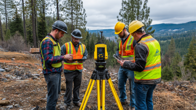
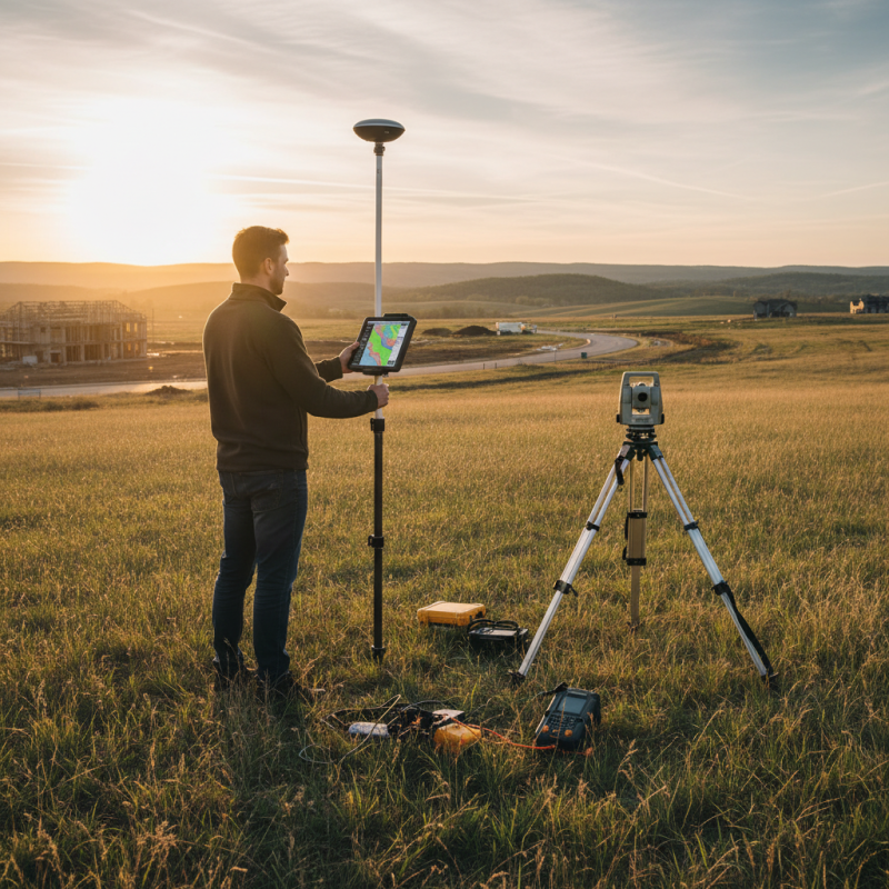
When it comes to modern surveying, precision really is the name of the game, especially with land measurements. Thanks to advancements like GNSS (Global Navigation Satellite System) technology, the industry has been turned upside down in a good way. Surveyors now can get incredibly accurate readings by using Real-Time Kinematic (RTK) positioning, which is a game-changer. If you're in the field—whether tackling construction projects, marking property boundaries, or doing geospatial work—having reliable Gnss Rtk gear is pretty much a must-have.
Choosing the right equipment, though, can be a bit overwhelming—there are so many options out there, especially if you're just starting out. That’s why I put together this quick rundown of the top seven GNSS Rtk Surveying tools that really stand out for their accuracy, features, and how user-friendly they are. Looking at these latest and greatest options should help you make smarter choices, improving your workflow and the accuracy of your land measurements.
At the end of the day, good surveying boils down to innovation, efficiency, and accuracy. Picking the right GNSS RTK device is a big step toward hitting those goals. So, let’s dive into the best tools on the market today—this could really help take your surveying skills to the next level!
Overview of GNSS RTK Surveying Technology
GNSS RTK (Global Navigation Satellite System Real-Time Kinematic) surveying technology has revolutionized precision land measurement by providing high accuracy and real-time data processing capabilities. This advanced technique utilizes satellite signals, corrections from a base station, and mobile rover units to achieve centimeter-level accuracy in positioning. According to a report by MarketsandMarkets, the Global Gnss market is expected to reach $209.2 billion by 2027, indicating strong growth driven by increased demand for precision in surveying and construction activities.
The effectiveness of Gnss Rtk Systems lies in their ability to mitigate errors associated with satellite positioning. By employing a network of ground-based reference stations, these systems correct the errors in GPS signals, enhancing the overall accuracy and reliability of measurements. Research indicates that RTK technology can achieve positioning accuracy within 1-2 centimeters, making it essential for applications such as land surveying, construction, and agricultural management. Furthermore, as infrastructure projects and land development continue to expand globally, the reliance on GNSS RTK systems is projected to increase, facilitating more efficient and precise land measurement processes.
Key Features to Consider in GNSS RTK Equipment
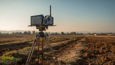
When selecting GNSS RTK Surveying Equipment for precision land measurement, several key features must be considered to ensure optimal performance and reliability. Firstly, accuracy is paramount; look for devices that provide centimeter-level precision to enhance the quality of survey data. Equipment should also support various GNSS constellations, such as GPS, GLONASS, Galileo, and BeiDou, allowing for improved signal reception and reliability in diverse environments.
In addition to accuracy, the ability to operate in challenging conditions is another critical factor. Ruggedness and weather resistance are essential in fieldwork scenarios where equipment might be exposed to harsh elements. Furthermore, consider the usability of the device; an intuitive interface and straightforward setup process can significantly reduce training time for survey teams.
Lastly, connectivity options, such as wireless data transmission and integration with existing software systems, can enhance workflow efficiency and data management capabilities, ensuring that the surveyed data is both accessible and actionable.
Top Brands and Models for GNSS RTK Surveying Gear
When it comes to GNSS RTK surveying gear, the right equipment can make a significant difference in achieving precision in land measurement. There are various brands and models available, each designed to cater to different surveying needs. The most prominent manufacturers in this field focus on delivering devices that provide high accuracy and reliability, enabling surveyors to collect data efficiently in diverse environments.
Top models in the GNSS RTK surveying market often emphasize features such as multi-constellation support, advanced algorithms to enhance signal reliability, and robust designs that withstand harsh conditions. Many of these systems also include user-friendly interfaces and offer compatibility with various software solutions, making data processing and analysis straightforward. With advancements in technology, newer models have integrated innovative functions that elevate the operational capabilities of surveyors, ensuring that precise land measurements are achievable on every project.
Top 7 GNSS RTK Surveying Equipment for Precision Land Measurement
| Model | Accuracy (cm) | Frequency Band (GHz) | Weight (kg) | Battery Life (hours) |
| Model A | 1.5 | 1.575 | 1.2 | 12 |
| Model B | 2.0 | 1.575 | 1.5 | 10 |
| Model C | 1.0 | 1.23 | 1.0 | 15 |
| Model D | 2.5 | 1.575 | 1.3 | 8 |
| Model E | 1.8 | 1.575 | 1.4 | 11 |
| Model F | 2.3 | 1.575 | 1.6 | 9 |
| Model G | 1.2 | 1.575 | 1.1 | 14 |
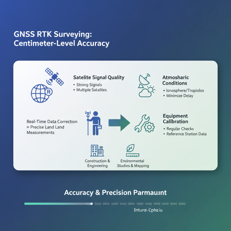
Accuracy and Precision in GNSS RTK Measurements
When it comes to GNSS RTK (Global Navigation Satellite System Real-Time Kinematic) surveying, accuracy and precision are paramount. These systems leverage satellite technology to determine positions with remarkable accuracy, often within centimeters. The effectiveness of GNSS RTK measurements hinges on multiple factors, including satellite signal quality, atmospheric conditions, and equipment calibration. By employing real-time data correction techniques, surveyors can minimize errors and achieve precise land measurements, which are essential for a range of applications from construction to environmental studies.
Moreover, the integration of advanced algorithms and robust networking capabilities enhances the reliability of GNSS RTK systems. Users can take advantage of base station deployments and continuous correction signals that allow for real-time processing and immediate feedback. This level of precision is crucial in surveying tasks, as any discrepancies can lead to significant complications during land development or infrastructure projects. Consequently, selecting the right GNSS RTK equipment is vital for achieving the highest standards in measurement accuracy, ensuring that survey outcomes meet rigorous industry requirements.
Applications of GNSS RTK Surveying in Different Industries
GNSS RTK (Global Navigation Satellite System Real-Time Kinematic) surveying technology is becoming increasingly essential across various industries due to its capability for high precision land measurement. In the construction sector, for instance, the accuracy provided by GNSS RTK systems ensures that project layouts are aligned perfectly with design specifications. According to the International Federation of Surveyors (FIG), the precision in positioning can reach within centimeters, which significantly minimizes material wastage and labor costs. This accuracy is pivotal in large-scale infrastructure projects like roads, bridges, and buildings, where even minor deviations can lead to substantial financial repercussions.
Similarly, agriculture is leveraging GNSS RTK for precision farming practices. A report from the Food and Agriculture Organization (FAO) indicates that precision agriculture can lead to yield increases of 5-15% by optimizing land use and resource allocation. By employing GNSS RTK systems, farmers can achieve more accurate field mapping, enabling them to apply fertilizers and pesticides more effectively, thus enhancing crop production while minimizing environmental impact. This intersection of technology and agriculture not only promotes sustainability but also increases profitability for farmers, showcasing the versatile applications of GNSS RTK surveying in enhancing productivity across various sectors.
Maintenance and Calibration of GNSS RTK Equipment
Maintenance and calibration of GNSS RTK equipment are critical components in ensuring the accuracy and reliability of precision land measurements. Regular maintenance practices help to extend the lifespan of the equipment and prevent unexpected failures during surveying tasks. Operators should routinely inspect components such as antennas, receivers, and batteries. This includes checking for physical damage, ensuring that connections are secure, and cleaning surfaces to avoid interference from dirt or debris. Additionally, software updates should be performed as needed to incorporate enhancements and address any identified issues.
Calibration of GNSS RTK equipment is equally important, as it aligns the system to specific reference points for optimal performance. This process typically involves comparing the measurements gathered by the RTK system with known positions to identify and correct any discrepancies. Depending on the complexity of the surveying work, calibration can be performed daily or at regular intervals. Implementing a robust calibration schedule not only improves measurement accuracy but also instills confidence in the data collected, thereby enhancing project outcomes. Proper training and adherence to best practices in maintenance and calibration will ultimately lead to higher precision in land measurements, ensuring that surveyors can deliver reliable results to their clients.
Top 7 GNSS RTK Surveying Equipment - Surveying Precision Comparison
Future Trends in GNSS RTK Surveying Technologies
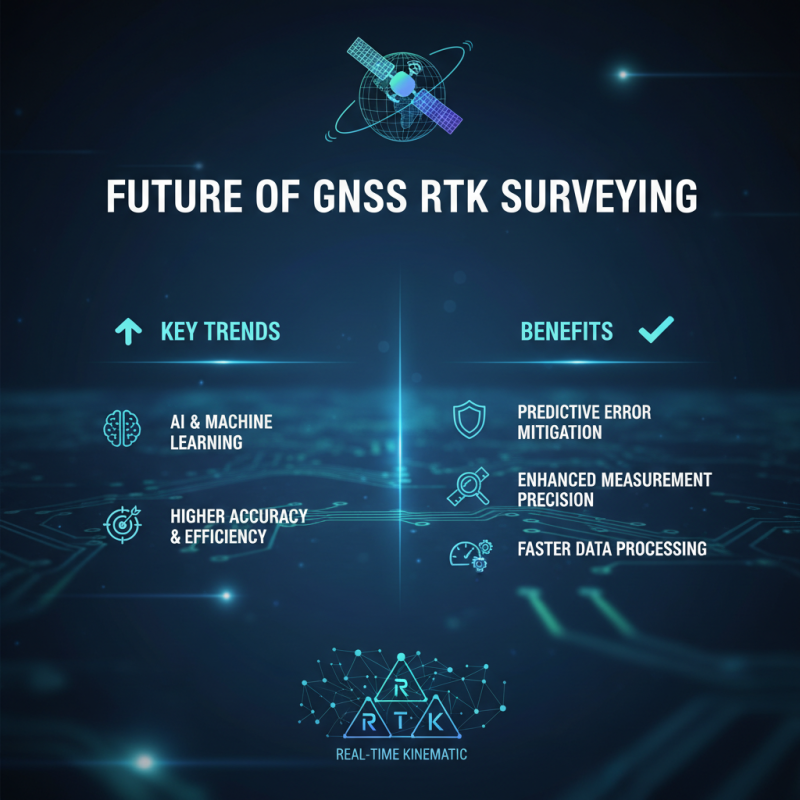
The future of GNSS RTK surveying technologies is poised for significant advancements, driven by increasing demand for higher accuracy and efficiency in land measurement. One of the most notable trends is the integration of artificial intelligence and machine learning algorithms into GNSS systems. These technologies enable predictive analytics, allowing surveyors to anticipate and mitigate errors in real-time, leading to enhanced precision in measurement and faster data processing.
Another key trend is the expansion of multi-frequency GNSS signals. This innovation allows receivers to utilize signals from multiple satellites simultaneously, improving reliability and accuracy even in challenging environments. As more countries invest in creating and maintaining their own satellite systems, access to diverse GNSS signals will ensure that surveyors can achieve centimeter-level accuracy in various geographical settings.
Tips: When considering upgrades to your surveying equipment, look for compatibility with emerging technologies such as 5G and advanced GNSS networks. Staying informed about these innovations will help you maintain a competitive edge in precision measurement. Additionally, invest in training for your team to adapt quickly to new tools and methodologies, ensuring your organization can fully leverage these advancements.
Harnessing Precision: Exploring the Features of Apeks Stylus Pens and the Android 10 Control GNSS RTK Controller for GIS Applications
In the ever-evolving landscape of Geographic Information Systems (GIS), the integration of advanced tools such as the Apeks Stylus Pens and Android 10 Control GNSS RTK Controllers has revolutionized data collection and analysis. The Android 10 operating system, equipped with GMS and AR Core capabilities, allows users to harness augmented reality features, facilitating enhanced interaction with spatial data. This is particularly pivotal in GIS applications where precision and user experience are paramount.
Central to these advancements is the UM980 motherboard, leveraging a powerful 2.0 GHz industrial processor. This enables the seamless processing of complex GIS algorithms while maintaining energy efficiency. Coupled with a robust 9000mAh battery, users can expect prolonged operational periods, allowing for extensive fieldwork without frequent recharges. Furthermore, the device features advanced memory specifications with 64GB of ROM and 4GB of DDR4 RAM, ensuring high-speed data handling and storage, critical for managing extensive geospatial datasets.
The new design with a Corti keyboard enhances user ergonomics, increasing efficiency during data entry and navigation. As reported by industry analysts, precision in data acquisition and interpretation can lead to significant improvements in decision-making processes. By employing tools like the Android 10 Control GNSS RTK Controller in conjunction with the Apeks Stylus Pens, GIS professionals can expect a new standard of accuracy and reliability, streamlining workflows and enhancing overall productivity in the field.
FAQS
: GNSS RTK (Global Navigation Satellite System Real-Time Kinematic) surveying technology is an advanced technique that provides high accuracy in land measurement by utilizing satellite signals and corrections from a base station, enabling centimeter-level positioning precision.
GNSS RTK improves measurement accuracy by employing ground-based reference stations that correct errors in GPS signals, enhancing the reliability and precision of the measurements taken.
GNSS RTK technology can achieve positioning accuracy within 1-2 centimeters, making it highly effective for applications like land surveying, construction, and agricultural management.
Key features to consider include accuracy (centimeter-level precision), compatibility with multiple GNSS constellations, ruggedness for challenging conditions, user-friendly interface, and connectivity options for data management.
Ruggedness is important because GNSS RTK equipment may be exposed to harsh elements during fieldwork, and durable equipment can ensure reliable performance in challenging conditions.
Connectivity options, such as wireless data transmission and integration with existing software, can enhance workflow efficiency by making surveyed data more accessible and actionable for users.
GNSS RTK technology is beneficial for various industries, including land surveying, construction, and agricultural management, where precision measurement is crucial.
The global GNSS market is expected to reach $209.2 billion by 2027, driven by increasing demand for precision in surveying and construction activities.
GNSS RTK contributes to land development and infrastructure projects by facilitating more efficient and precise land measurement processes, essential for successful project execution.
An intuitive interface is important because it can significantly reduce training time for survey teams, enabling quicker and more efficient operation of the equipment in the field.
Conclusion
GNSS RTK surveying equipment has revolutionized precision land measurement by providing highly accurate positioning data in real-time. This technology utilizes satellite signals to deliver centimeter-level accuracy, making it essential for various applications across multiple industries, such as construction, agriculture, and mapping. When selecting GNSS RTK equipment, it is crucial to consider key features such as the receiver's capability, software compatibility, and durability to ensure optimal performance.
The effectiveness of GNSS RTK surveying equipment is significantly impacted by maintenance and regular calibration, ensuring reliable results throughout its use. As the industry advances, emerging trends in GNSS RTK technology promise to enhance accuracy and efficiency, paving the way for even broader applications and innovations in land management and survey work. Understanding these aspects is vital for professionals looking to leverage the full potential of GNSS RTK surveying in their projects.